


|
|
| Tel: +61 423 601 604 - Email: architect@andrewtboyne.com |
 |
||
|
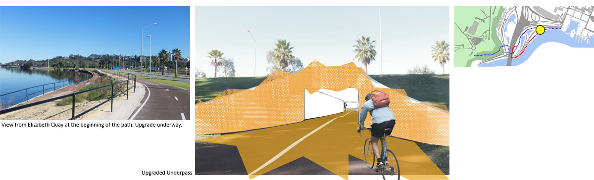
The completion of Elizabeth Quay on Perth’s Swan River provides a brand-new tourist and community hub for the city. Access to the Quay bleeds out of the central business district towards the river, and visitors are provided with open spaces, a connection to the river, café’s and kiosks. Even though the Quay is just 1km from Perth’s greatest asset of Kings Park there is no easy way to get between the two. This proposal envisions a walking path that connects the two attractions by utilising existing infrastructure, and inserting a number of small interventions to clarify the connection, and to create a pleasant, clear and strong connection between the two. |
||
|
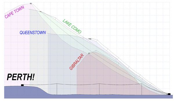
Alternative proposals to connect the two
destinations have considered the construction of a cable-car from the
Quay, up over the 60m scarp and through Kings Park. Even though this
proposal does address the poor connection between the two places there
has however been significant community opposition to this proposal. A
cable car will obscure King’s Park’s iconic views over the city and
freeway, it will cut into Kings Park which is Perth’s greatest asset, it
will be expensive to use, it wont transport many people and it will be
underwhelming in scale. The adjacent diagram compares a cable-car
between Elizabeth Quay and Kings Park to similar cable-cars around the
world. The comparison shows the
proposed Perth Cable-car lacks the height and steepness to create the
excitement that other cable-cars achieve. It also lacks an exclusive
destination that can only be assessed by the cable-car. Perth should play to its strengths. With a
wonderful climate, active outdoor culture and a beautiful river, a
walking path provides the perfect opportunity for visitors and perthites
alike to enjoy the riverfront as they transverse between the Quay and
the Park
|
 |
|
|
There are existing pathways
along the river, but they are incoherent and do not form a strong
connection between the Park and the Quay. The biggest obstacle to
connect the two destinations is the Mt Eliza Scarp. An existing pathway
does exist up the scarp but it has been closed for some time and is now
overgrown. This proposal intends
to re-open the Hackett path and re-utilize the existing infrastructure,
and to enhance the quality of the connection between the Park and the
Quay by installing 10 small interventions that enhance the cohesiveness
of the trail. |
||
 |
||
|
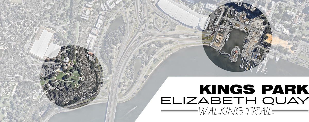
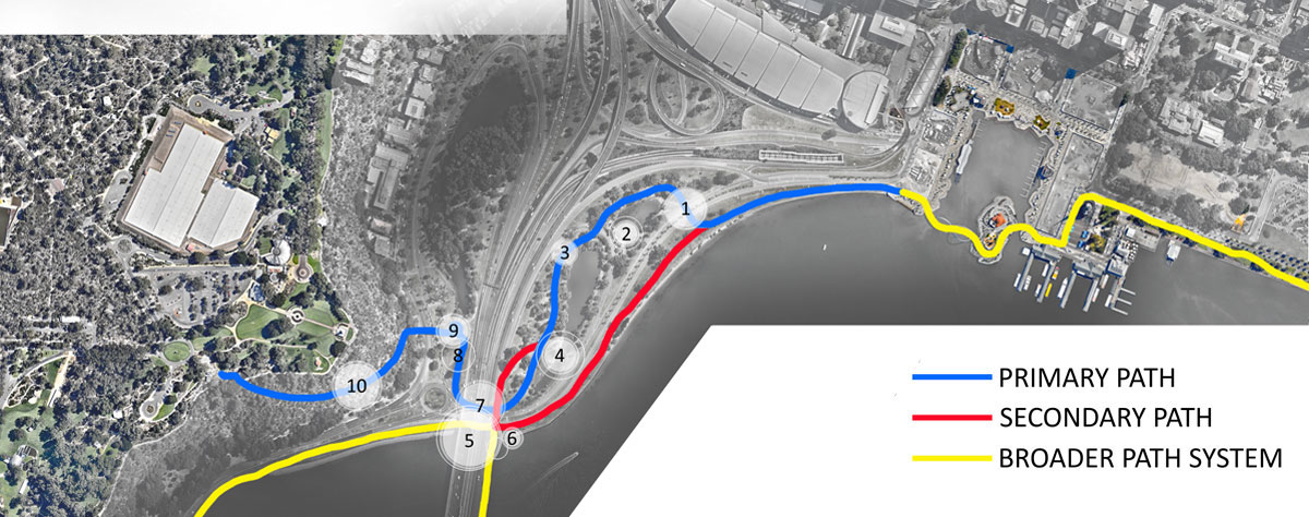
The walking trail consists of two paths. The
primary path weaves it’s way through the lakes that lie between the
freeway interchange, and the secondary path runs along the river’s edge
before reconnecting the primary path at the freeway underpass via a
pedestrian overpass. The combined path then crosses under the freeway,
over an existing pedestrian overpass and up a newly refurbished Hackett
path. The benefit of the new walking path is more than a simple link between two destinations, but acts as a critical addition to an already extensive network of walking paths around Perth and it’s river. Since the closure of the Hackett Path, Kings park has been largely isolated from this network, but by opening the path, and improving infrastructure the park can now be linked to destinations such as South Perth, the Zoo, Matilda Bay, East Perth, and even Burswood and the new Stadium. Not only does the pedestrian link make sense in itself, it also strengthens an existing network of paths.
|
||
|
INTERVENTION 1 - Underpass Rennovation |
||
|
|
||
|
From Elizabeth Quay the
path to Kingspark is reasonably clear and is currently being upgraded.
This point marks the beginning of the Primary and secondary path. 350m
along the path, the Primary path turns right through an existing
underpass. To identify the path a renovation of the underpass is
proposed. This may include introduction of colour, lighting and
improvement of materiality to brighten the passage. The passage would
then act as a marker for the path an entice walkers into the lakes
beyond.
|
||
|
|
||
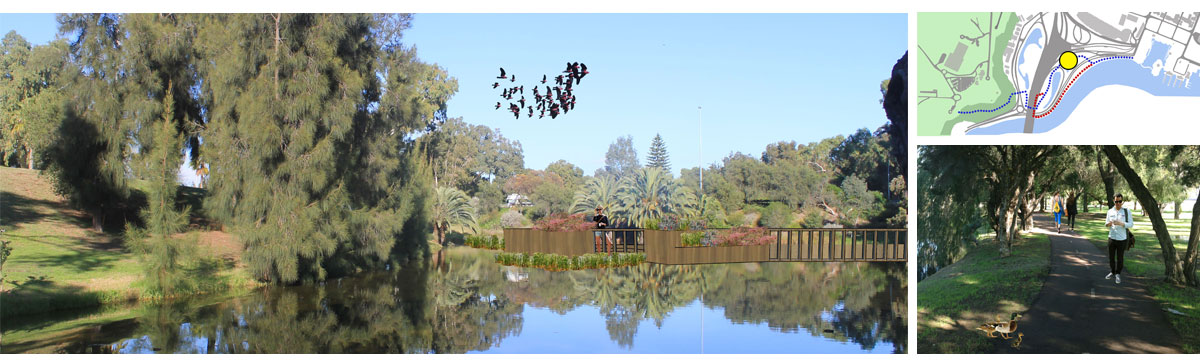 |
The Lakes between the freeway interchanges are
remarkably peaceful and provide an enclosed counterpoint to the vast
open spaces along the exposed river. These lakes are home to birdlife
and are protected from the wind. On hot days the almost constant shaded
canopy provides shade and respite from Western Australian blazing sun.
The lakes offer a quiet recreation space just 400m from Elizabeth Quay
where hotels and apartment buildings ensure that many thousands of
residents will reside. As part of the enhancement of the path we propose a small platform is built along the southern end of the first lake as a quiet resting place that connects with the water of the lake. This platform will be good for observing birds, and acts as a point of interest along the path.
|
|
| INTERVENTION 3 - Acoustic Wall | ||
 |
||
|
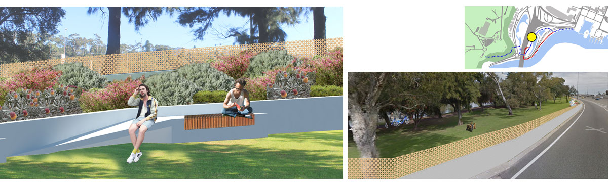
The Southern lake, approached after the northern
lake is less protected from the noise of the freeway. This can be
overcome by constructing a concrete acoustic barrier along the boundary
with the freeway. This wall can be complimented with an acoustic baffle
which can be cut in patterns and present an appealing dynamic appearance
to the freeway. There are opportunities to build in seating for respite
and to introduce planting to soften the edge of the park.
|
||
| INTERVENTION 4 - Floating Garden | ||
 |
||
|
At the southern end of the southern lake we propose to build a platform with a floating garden. The lake at this point does often overflow into the surrounding grasses. We propose to turn this area into a reed bed that helps to clean the water before it possibly gets washed into the river. A platform can be built out amongst the reed garden and provides another point of interest along the path.
|
||
|
INTERVENTION 5 - Fishing Platform |
||
 |
||
|
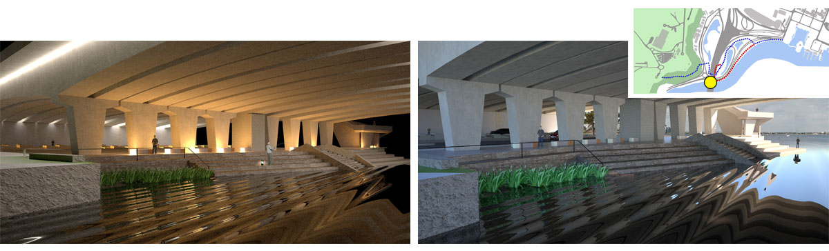
The fishing platform is proposed under the Narrows Bridge after following the secondary path along the riverfront. The space has long been used by fisherman who pull up their vehicles and fish from brick walls while using lanterns for light. This area is currently neglected. We propose a terraced fishing platform below the bridge that allows anglers an opportunity to get down to the water. The platform will include new paving and lighting to clean up the area so that it is an asset to the city. The intervention will include fish cleaning stations and waste receptacles so that it remains in a good condition. Parking for the platform will be located on Mounts Bay road. |
||
|
INTERVENTION 6 - Overpass Stair |
||
 |
||
|
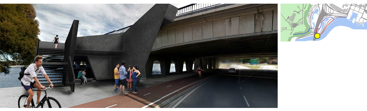
An existing level-crossing on the eastern side of
the Narrows Bridge helps to provide connection between the primary and
secondary paths but is frequently congested by cyclists and can be
dangerous for pedestrians because of poor site lines and the speed of
vehicles moving through the area. A pedestrian stair is proposed just on
the eastern side of the Fishing Platform and allows pedestrians to get
up to the deck level of the Narrows Bridge and use the existing
pedestrian footpath to cross over the road. This path will be maintained
as it slopes down and joins the primary path adjacent to the southern
lake. The pedestrian stair allows the Primary and Secondary paths to
meet without having to cross a road.
|
||
|
INTERVENTION 7 - Freeway Underpass |
||
 |
||
|
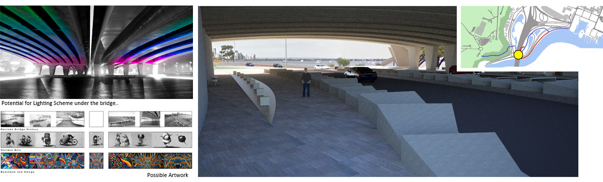
Currently the freeway underpass under the Narrows
Bridge is a large sandy pit, filled with car noise. The area is
difficult to traverse because of bicycles speeding through, and
generally feels neglected. This area is probably one of the least
pleasant parts of the existing infrastructure that is required to make
the new walking path work. The area requires a significant upgrade. We propose a series of sculptural bollards that run
along the kerb of the road to separate car traffic from pedestrians.
These bollards can be designed in a way that they don’t present a danger
to traffic and can be fitted with lighting. The path under the bridge
can be further divided into dedicated paths for cyclists and
pedestrians. Through a series of light fixtures that ensure that the
space is not daunting at night. In addition to floor mounted lighting we
propose that a coloured lighting scheme be projected along the ribs of
the Narrows Bridge. This bridge has beautiful subtle curves which would
perform well with additional light. This approach to lighting will add a
point of interest along the path. The existing underpass has a long empty wall that is dirty and neglected. Along with new paving throughout the area we believe that we should be upgrading the wall by introducing artwork from local artists. Artwork could incorporate historical imagery, pattern or a contemporary narrative.
|
||
|
INTERVENTION 8 - Freeway Shoulder |
||
 |
||
|
After exiting from the freeway underpass the path
takes a sharp right. At the moment the flat red bituminised path,
surrounded by grass lacks any strength or identity and doesn’t provide a
clear indication that the path continues. By cutting into the existing
shoulder with a strong retaining wall the direction of the path is
reinforced. By cutting a new path around the corner we are able to keep
the definition between pedestrians and cyclists around a corner with
otherwise poor visibility.
|
||
|
INTERVENTION 9 - Overpass Rennovation |
||
 |
||
|
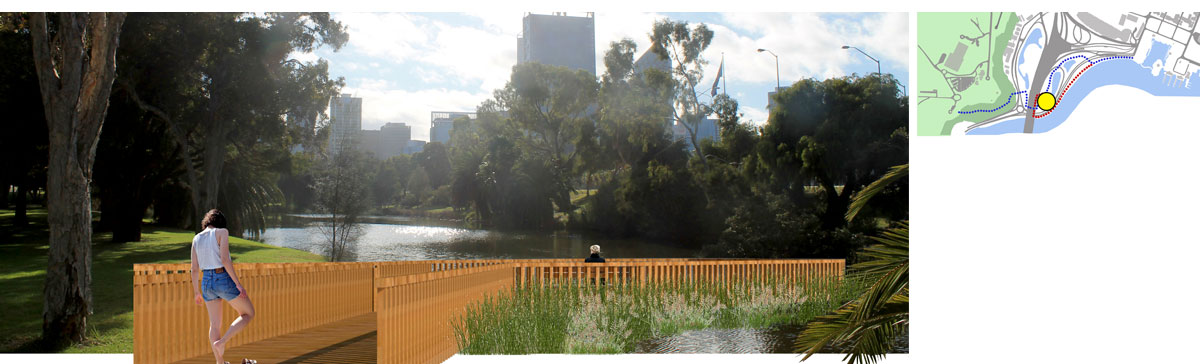
An existing concrete overpass spirals out of the grass just after the freeway shoulder and lands on the lower slopes of the Mt Eliza scarp immediately below the Hackett Path. The overpass itself is an elegant structure but has been neglected as it no longer serves a clear purpose since the closing of the path up to Kings Park. In it’s current setting, surrounded by grass, the helical ramp, and the bridge itself feels isolated and of little consequence. To improve it’s importance, and to make it a legible part of the new path we propose extending the lake immediately to it’s north under the bridge ramp itself. By strengthening the bridge’s sense of place, the strength of the overall path is improved. |
||
|
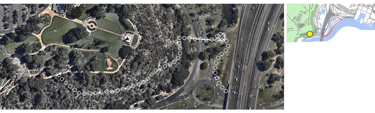
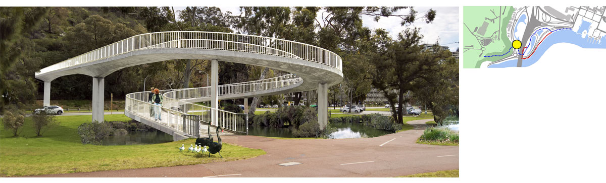
INTERVENTION 10 - Re-building Hackett Path |
||
|
|
||
|
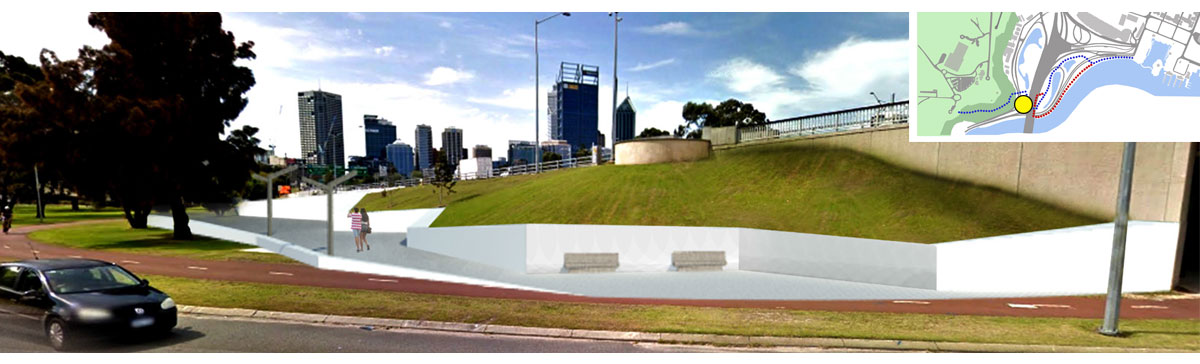
Hackett Path is the
critical piece of infrastructure that ensures the path between Elizabeth
Quay and kings Park is successful. Without it the only ways to get to
the park are via the Kakoda Track of Jacobs Ladder, both of which are
some distance away and at gradients that are far too steep. Hackett path
itself once provided a link between the overpass and the park via a
relatively evenly terrace that runs up the hill at a comfortable
gradient. The path was closed in the early 2000s after the scarp
exhibited signs of erosion and experienced isolated rock slides. The
path itself is now overgrown. We believe that the establishment of
Elizabeth Quay, and the need to link the two major tourist assets gives
new emphasis to the case to re-open Hackett Path. With careful design, a
new path may ultimately help to further stabilise the cliff and
eliminate any future erosion.
|
||
|
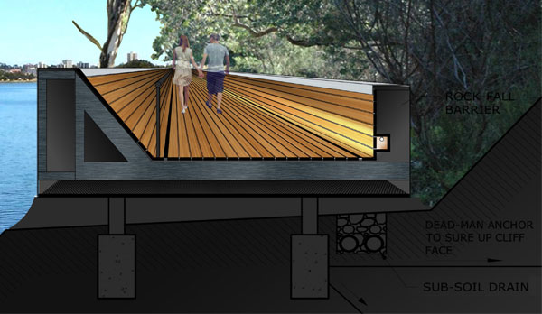
Because re-opening the Hackett path allows a direct
connection via a walking path between the two major assets of the city
of Perth, the path itself should be considered as a critical piece of
infrastructure that adds to both assets. Subsequently we believe that
the path should be a very high priority, and be developed beyond the
simple rough path that was originally closed. By raising the path in a
boardwalk fashion, building in balustrades on the down-hill side and
rock fall barriers on the uphill side, installing new drainage, and
using footing design to sure up the face of the scarp we believe that
the stability of the scarp itself can be enhanced through the renovation
of Hackett Path. This boardwalk could be used intermittently where
the scarp is not in a stable condition or it could run continuously up
the route of the old Hackett path. The path itself has sweeping views
over the Swan Estuary, and can be provided with resting points for
respite and photography. The boardwalk could be on grade at all points or at
some points it could leave the ground and become a bridge, which would
tie in nicely with the existing tree-top walk.
|
 |
|
 |
 |
|
|
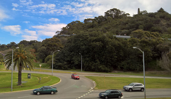
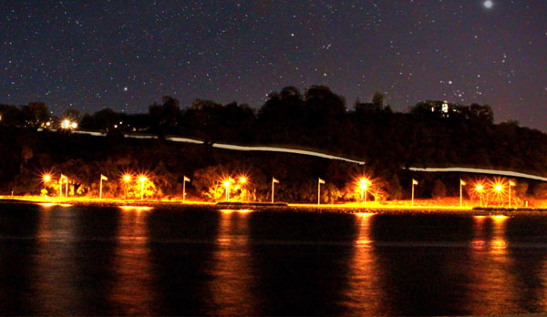
The path itself also allows interesting opportunities as to how it presents to the city from afar. It could be designed to be discrete and anonymous, but it could also be prominent, appearing as a line of light cutting through the scarp. At night it could be illuminated so that it appeared as a laser line across the darkness when travelling north up the freeway to the city. The opportunity to provide the path with some prominence may satisfy the desire for an “iconic” tourist attraction which has fuelled the consideration of the cable car proposal. |
||
|
Conclusion and Credits |
||
|
The proposal outlined above provides an opportunity
to create a substantial link between Perth’s two major tourist and
community assets that is otherwise unavailable. Unlike alternative
proposals for a cable-car this proposal is based on the actual assets
that are available, and the opportunities they provide. A walking path
is not only consistent with the lifestyle, climate and setting of the
city and the river, but it is also consistent with developing trends in
urban development. Many cities around the world are establishing walking
trails and selling them as tourist experiences. We believe that a
walking path that is only a little over a kilometre long, has a vertical
gain of only 60m, is through a picturesque riverside landscape, and
links two major pieces of tourist infrastructure, is a sure winner. The ten interventions in this design are indicative
of what might be prioritised when a thorough feasibility study is
undertaken in consultation with appropriate stakeholders. The beauty
with the proposal is that most of the infrastructure is already existing
which should reduce any costs of the development, but it also enhances
existing systems of walking trails, meaning that the benefit of this
development will be far greater than a simple link between the two
destinations. We believe that the proposal for a walking trail
between Elizabeth Quay and Kings park will bring a great benefit to the
city, it’s community and it’s tourists and are eager to develop the idea
further. Please contact Andrew T Boyne Architect for any further
information. This project was completed
by Andrew T Boyne Architect with the assistance of Sean Heath and
Rachael Tallon.
|
||
 |
 |
 |
 |